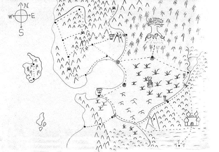
Lately, my older son has decided that his favorite game is for me to draw maps for him. After a handful of treasure maps, he decided that we should draw a “regular map”, and we collectively improvised the map attached here. I drew a coastline, and then he would suggest things, and I would suggest other things, and the map just sort of filled itself in, along with accompanying backstory. This may be the most fun game I have ever played with Jack.
The main geopolitical issue in the mapped area is how the various human towns near the great swamp seen in the center right defend themselves against attacks by the Serpent Folk, whose fortress can be seen in the middle of the swamp. The kingdom which lays claim to the entire area has nominal responsibility for the towns’ defense, but in practice the towns on the far side of the swamp from the capital (the circle-with-star at the top of the bay) are defended by towers manned by the Order of Assassins, whose fortress can be seen at the edge of the desert in the lower right. A town along the north edge of the swamp, meanwhile, depends on the elves of the forest for its defense. The Great Tree of the elves appears in the middle of the forest (and is not drawn to scale).
Other notable features include the two mountains north of the human capital, each of which houses a mighty dragon. There is a royal fortress in the valley below to keep an eye on the beasts. There is another, larger double mountain in the south, west of the Assassin fortress, which has a mysterious cave near its summit, at the end of a long and winding path. There is also an inexplicable tropical island off the coast. We know little about it, other than that it definitely has monkeys.